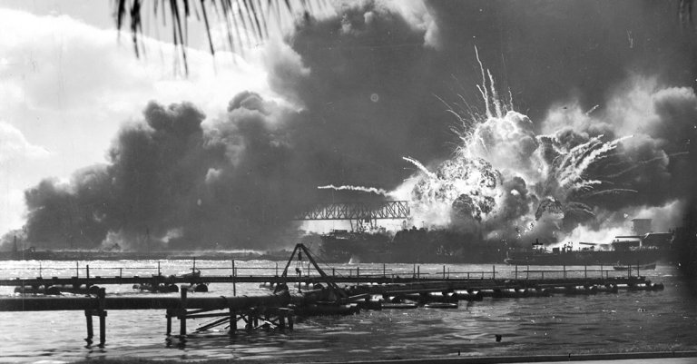
More than 80 years ago, the USS Yorktown took a pair of torpedo hits from the Japanese submarine I-168 and slipped to the bottom of the Pacific Ocean. She came to rest nearly three miles down, taking 141 of her crew with her.
The rest of her story—the Coral Sea, the improbable 72-hour repair at Pearl Harbor, the strikes that sent three Japanese carriers to the bottom at Midway—is well documented. What wasn’t as well-documented was the massive mural painted somewhere deep in her guts, a mural that depicted the ship’s entire story. It hadn’t been seen since the ship went down in June 1942.
That all changed.
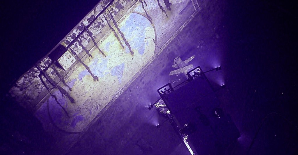
In April 2025, NOAA Ocean Exploration researchers completed the first full imaging of “A Chart of the Cruises of the USS Yorktown,” a hand-painted mural stretching 42 feet long and 12 feet tall, covering the wall of one of the ship’s elevator shafts. The sailor who painted it picked a strange canvas, but it somehow remains preserved under the waves a full eight decades later.
The mural is a world map tracing the Yorktown’s voyages from her commissioning in 1937, right up to the moment she was torpedoed in 1942. Landmasses are in blue, oceans in white, the whole thing framed in a border of aircraft propellers. It’s a pictorial history of deployments, operations, and the corners of the globe the ship and her crew reached together.
Unfortunately, nobody signed it. Historians believe it was painted by a crew member. Nothing commissioned, nothing official, just someone with a little talent and a lot of pride with something to say about his ship.
The mural wasn’t a secret; it was meant to be seen. World War II photographs showed pieces of it. But the full picture had been sealed in darkness three miles down ever since the ship was sunk. NOAA’s remotely operated vehicles changed that, capturing complete images for the first time since the carrier went down.
Top Stories
Sitting 5,000 meters below the surface, the colors are still vibrant. The outlines are crisp. A few rust streaks have crept down the steel walls over time, but the mural itself looks like someone could still be standing in front of it, pointing to a spot on the map and talking about what happened there.
The Battle of Midway is studied for American intelligence successes and U.S. Navy heroics. It was a stunning early victory that needed broken codes, an ambush, and the improbable reversal of fortune that finally stopped Japan’s advance. The Yorktown’s role is usually framed in those terms. She was the ship the Japanese didn’t know about, the phantom carrier that ultimately cost them the battle.
But Yorktown was more than a warship; she was a little floating world, and the mural is a reminder that the vessel was home to thousands of men who lived, worked, and built something that felt like home. Someone took the time to paint a 42-foot map because the journey was important to those men aboard.

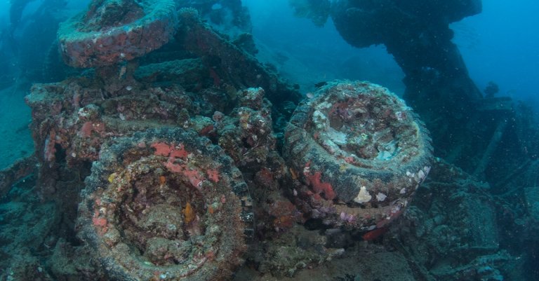
NOAA also documented aircraft preserved inside the wreck and, in what has to be the most unexpected finding of any deep-sea expedition, a 1940–41 Ford Super Deluxe “Woody” station wagon stored in the hangar deck.
Today, a 3D model of the mural is available through NOAA Ocean Exploration. You can see the whole thing without disturbing a single rivet of the ship where it lives.
It’s still down there in the dark, just a time capsule under the waves. It’s a map of where they’d been, painted by someone who wanted to make sure it wasn’t forgotten.
You can still watch the entire dive, annotated and clickable directly to the mural at the Ocean Networks Canada Dive Log.
Don’t Miss the Best of We Are The Mighty
• Patton’s famous speech was way more vulgar than the one in the movie
• The John Frum Movement and World War II ‘cargo cults’
• This Marine survived the Bataan Death March, a ship sinking, and an atomic bomb