It’s easy now to think of Operation Overlord as fated, like it was the armies of Middle Earth hitting Mordor. The good guys would attack, they would win, and the war would end. But it actually fell to a cadre of hundreds of officers to make it happen and make it successful, or else more than 150,000 men would die for nothing.

But the planners of Operation Neptune and Operation Overlord had an insane number of factors to look at as weather, moon and starlight, and troops movements from London to Paris would affect the state of play when the first Allied ships were spotted by Axis planes and lookouts. Planners wanted as many factors on their side as possible when the first German cry went out.
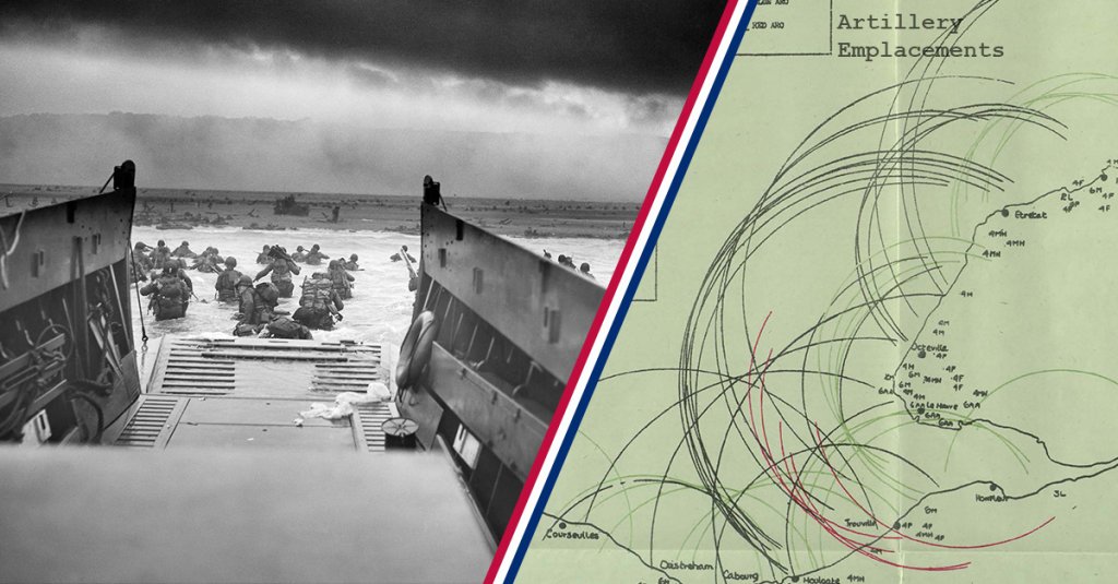
The map above allowed the planners to get a look at what sort of artillery emplacements troops would face at each beach, both during their approaches and landings and once they were on the soil of France.
Looking at all the overlapping arcs, it’s easy to see why they asked the Rangers to conduct the dangerous climbs at Point Du Hoc, why they sent paratroopers like the Band of Brothers against inland guns, and why they had hoped for much more successful bombing runs against the guns than they ultimately got.
Instead, paratroopers and other ground troops would have to break many of the enemy guns one at a time with infantry assaults and counter-artillery missions.

Speaking of those bombers, this is one of the maps they used to plan aircraft sorties. The arcs across southern England indicate distances from Bayeux, France, a town just south of the boundary between Omaha and Gold beaches. The numbers in England indicated the locations of airfields and how many fighter squadrons could be based at each.
These fighter squadrons would escort the bombers over the channel and perform strafing missions against ground targets. Bayeux was a good single point to measure from, as nearly all troops would be landing within 30 miles of that city.
But planners were also desperate to make Germany believe that another, larger attacking force was coming elsewhere, so planes not in range of the actual beaches were sent far and wide to bomb a multitude of other targets, as seen below.

Diversion attacks were launched toward troops based near Calais, the deepwater port that was the target in numerous deception operations. But the bulk of bomber and fighter support went right to the beaches where troops were landing.
Bombings conducted in the months ahead of D-Day had reduced Germany’s industrial output and weakened some troop concentrations, but the bulk of German forces were still ready to fight. Luckily, the Allies had a huge advantage in terms of weather forecasting against the Axis, and many German troops thought the elements would keep them safe from attack in early June, that is until paratroopers were landing all around them.

This map shows additional beaches between the Somme and the Seine Rivers of France along with the length of each beach. These beaches are all to the northeast of the targets of D-Day, and troops never assaulted them from the sea like they did on Utah, Omaha, Gold, Juno, and Sword beaches.
But these beaches, liberated by maneuvering forces that landed at the D-Day beaches, would provide additional landing places for supplies until deepwater ports could be taken and held.
But all of that relied on actually taking and holding the first five beaches, something which actually hinged quite a bit on weather forecasting, as hinted above. In fact, this next two-page document is all about meetings on June 4-5, 1944, detailing weather discussions taking place between all of the most senior officers taking part in the invasion, all two-stars or above.
(Maj. Gen. H.R. Bull, the memo author, uses days of the week extensively in the memo. D-Day, June 6, 1944, was the Tuesday he was referring to. “Monday” was the June 5 original invasion date. Wednesday, Thursday, and Friday were D-Day+1, +2, and +3.)


This might seem like a lot of military brainpower to dedicate to whether or not it was raining, but the winds, waves, and clouds affected towing operations, the landing boats, fighter and bomber cover, and the soil the troops would fight on.
The fate of France could’ve been won or lost in a few inches of precipitation, a few waves large enough to swamp the low-lying landing craft, or even low cloud cover that would throw off even more bombs and paratroopers. So, yeah, they held early morning and late night meetings about the weather.
Thank God.